
[Audioguide]
This collection, donated by the Juri family, explores American cartography from 16th Century up to 20th Century.
The exhibition is divided into sections where maps are accompanied with documents, engravings, postcards and books to represent the historical context in which they were produced.
Here cartography is presented as reflection on the group of notions transmitted through the educational system which are felt as part of the collective cultural heritage. This exhibition represents two central points: first, how the present international borders were defined and second, the ethnic composition and the demographic analysis of the population.
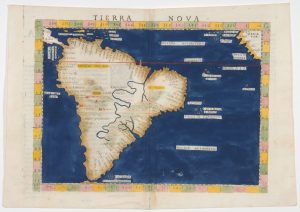
4 – A. Tierra Nova by Girolamo Ruscelli, 1561
Copper-plate intaglio and hand-coloured
[Audioguide]
Girolamo Ruscelli was a prominent Italian writer and editor of his time. As a cartographer, one of his most notable works is this engraving.
“Tierra Nova” (New World) was printed in Venice in 1561, and was thus named due to the very recent European arrival in America. It covers South America and part of Central America, showing a few islands in the Caribbean. It also depicts a small region of the west coast of Africa, along with some islands off the west coast.
It represents parallels and meridians, the equator and the tropic of Capricorn. Along the coastlines, we observe the names of numerous places, sometimes upside down to favour different ways of reading. Inland, the Amazon River is depicted as running south to north, and it originates below the Plata River. The range of the Andes Mountains is represented much shorter than its true topography. A few cities are mentioned like Cancha, Cusco and Xauca.
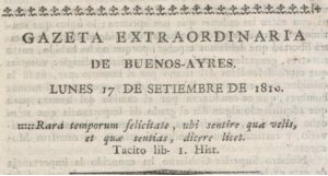
4 – B. Buenos Aires Gazette
Special edition, 17th of September 1810
[Audioguide]
The “Buenos Aires Gazette” was the first press organ publishing patriotic ideas. Many historical personalities very influential during the Independence process participated in the different editions, like Juan José Castelli, Manuel Belgrano, Manuel Alberti, Pedro Agrelo, Dean Gregorio Funes, Bernardo de Monteagudo, among others.
Its motto, from a quote by Tacitus, translates “Such was the happiness of the times, that you might think as you chose and speak as thought”.
The Gazette was printed in the “Real Imprenta de los Niños Expósitos”(The Royal Printing House for the Foundling). Viceroy Vértiz had founded this Printing House in a Foundling Hospital to provide the children with some income and learn a trade. To start the business he bought the press the Jesuits had in the School of Monserrat here in Córdoba.
The Gazette’s last edition was on September 12th 1821.
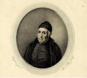
4 – C. Essay on Civil History of Paraguay, Buenos Aires and Tucuman (Gregorio Funes- 1816)
[Audioguide]
Dean Gregorio Funes (Córdoba 1749- Buenos AIres 1829) was a prominent clergyman, politician and chronicler of his time. He graduated as Doctor of Law from our University and he was proclaimed Rector in 1808. He was the first american-born person to hold this position, during the Secular Clergy Stage (1808-1820).
His book “Essay on Civil History of Paraguay, Buenos Aires and Tucuman” constituted the first interpretation of the historical process that led to the “Revolución de Mayo” and then to the Independence.
In 2002 this work was distinguished by the Congress of Argentina by establishing 1st of July (as “Historian’s day”)
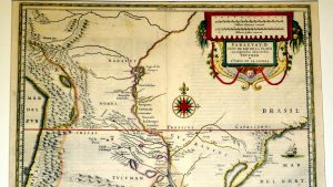
4 – D. Paraguay or Province of Río de la Plata, with adjacent regions of Tucuman and Santa Cruz de la Sierra (Diego de Torres)
[Audioguide]
Jan Jensen published this map attributed to Diego de Torres, the first Provincial (highest position) in the Jesuit province of Paraguay.
This early map of the Rio de la Plata Region shows excellent topographical details. It depicts main geographical accidents and the political divisions of the three Gobernaciones (subdivision of the viceroyalty) included in the Jesuit Province of Paraguay. The Province of Paraguay was an administrative division of the Society of Jesus that had its head in Córdoba. It existed up to 1767, when the Jesuits were expelled by the King of Spain.
We may observe the names of the cities and the ethnic groups (ethnonyms) in the region, like Guaraníes, Moxos, Chicas, Querandíes. Diaguitas and Juríes, among others. One of the main goals of the Society of Jesus in America consisted in the location of the indigenous populations for the further development of evangelising missions. This explains the prolific work of Jesuit mapmakers.