Navigating the Seas of the Renaissance:
The Terra Nova Map by Girolamo Ruscelli.
por Joaquín Rebuffo (1)
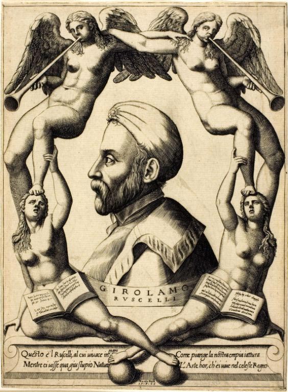
Girolamo Ruscelli, the Cartographer Behind the Map
As a writer, cartographer, and linguist, he was born in Viterbo at the beginning of the 16th century and died in Venice in 1566. He was highly educated and particularly skilled in grammatical studies. Ruscelli spent some years in Rome, where he founded the Academy of Sdegno. In 1548, he settled in Venice, where, according to him, he was highly admired. He excelled as a writer in various fields, and his main contribution was translating and disseminating the Geography of Claudius Ptolemy (1561).»
The Influence of Claudius Ptolemy’s ‘Geography’ on Modern Cartography
The “Terra Nova” map is part of an Italian reedition of the “Geography.” This book was originally written by Claudius Ptolemy in the 2nd century in Greece and remained hidden throughout the Middle Ages. After the fall of the Byzantine Empire, a copy arrived from Constantinople to Florence at the end of the 14th century, and quickly the “Geography” became a bestseller of the time, with 7 editions in the 15th century and 34 editions in the 16th century.
The appearance of this 2nd-century A.D. edition of the “Geography” laid the foundations for Modern Cartography, establishing the orientation of maps toward the north, the format of the Universal Atlas, the projection of a round earth, and the system of latitude and longitude coordinates. Ruscelli was one of those fascinated by Ptolemy’s work and devoted himself to translating and disseminating it, adding maps like “Terra Nova” that were not part of the original. Alongside Ruscelli, Giuseppe Moleto (1531-1588) and Vincenzo Valgrisi (1540-1572) worked on this publication.
Renaissance, Colonialism, and Cartography
The Renaissance, a period of great cultural and artistic transformation that took place in Europe between the 14th and 16th centuries, laid the foundations for the development of modern science. During this time, human thought underwent a radical change, shifting from a medieval mindset centered on religion to a more rational approach based on observation and experimentation. Unlike the medieval view, which considered that knowledge was obtained through divine revelation, the Renaissance promoted a more secular and reason-based perspective. Renaissance scientists began to question traditional beliefs and sought answers through other methods.
During the 17th century, advancements in cartography became a crucial tool for emerging colonial states. These more accurate and detailed maps allowed colonial powers to explore and exploit the natural resources of the new world more effectively. The creation of instruments such as the quadrant, sextant, and telescope, along with the printing press, facilitated the production of more precise maps that were rapidly disseminated among the higher social classes, including the crown, the nobility, and the clergy. Thus, cartography became a means to deepen the extraction of minerals, plants, and other valuable resources in the colonies. This period marked a significant shift in how geographical knowledge was understood and used, and its impact on colonial expansion was undeniable.
Navigating the Seas of the Renaissance: The Terra Nova Map
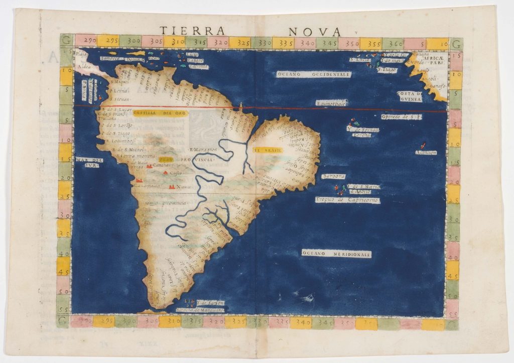
Before we begin to analyze the map in detail, it is important to clarify that this map belongs to a Universal Atlas, which primarily features regions of Europe, along with very summarized maps of America, Africa, and Asia. Therefore, some errors can be found in the exact positions on the coordinate plane, as the focus of the work is on Europe. Girolamo Ruscelli himself acknowledges the inaccuracies: «But as for all of this new world in particular, I will address it in my following universal editions. There is no need to say more here, except that Cusco is a province and also a great city that used to be the capital of this entire province, namely, Peru.” With this, Ruscelli is indicating that he is aware of some errors but will correct them in later editions.
It should also be noted that during this period, navigators used much more precise nautical charts, and in the case of the Spanish conquerors, they crossed the ocean using a copy of the «Padrón Real,» the official and secret cartography of the Spanish Crown. This means that Ruscelli’s Terra Nova map was not used by pirates and privateers, conquerors, or explorers for navigation, but rather served as an educational summary of what was «known» by Imperial Europe.
It is important to highlight that atlases, in addition to their educational function, were also symbols of status and refinement. Their meticulous production, with detailed illustrations and luxurious bindings, made them coveted items among the elite. Furthermore, by showcasing maps of distant and exotic regions, atlases sparked curiosity and the desire for exploration in those who owned them. These types of maps not only conveyed geographical knowledge of a certain region but also served as symbols of prestige and sophistication.
Notable Features of the Work…
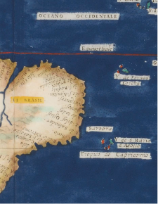
The map that we can observe in the room is hand-painted, an art known as “illumination”. This indicates that it belonged to a fully illuminated copy of Ptolemy’s Geography, significantly increasing its cost compared to black-and-white copies. Regarding toponymy, we found references to the Spanish governorships ‘Castilla de Oro’, ‘Peru’, ‘Quito’, and ‘Brazil’,. but it does not establish boundaries or distinctions between the Spanish and Portuguese crowns, nor between each of the governorships. This indicates the difficulty in accessing the information held by the Spanish Crown and the Portuguese Crown. Both powers were in a race to conquer the largest portion of the American continent, and due to the lack of technology to establish Latitude at sea, the Treaty of Tordesillas was not respected by either of the two imperial powers.
Continuing with the analysis, we can find at the bottom of the map the ‘Strait of Magellan,’ which divides the new continent with a portion of land still unknown that Ruscelli does not name. That portion is “Tierra del Fuego”, which, although some explorers had already circumnavigated it, there was still much uncertainty in Europe as to whether it was an island or was connected to a large continent known at that time as Terra Australis Incognita.
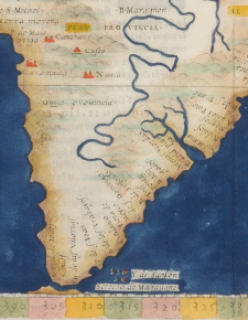
On the other hand, during the colonial period, the great rivers were important navigable routes for exploration and the extraction of natural resources, which explains why the Amazon appears oversized, crossing the entire continent, as does the Río de la Plata. We can also observe the presence of mountain ranges, which signified the possibility of finding precious metals highly coveted at that time.
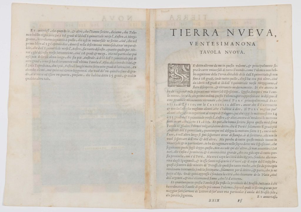
New Table. Translation of the Explanation of the Terra Nova Map, Present on the Reverse Side (2)
Elsewhere in my volume, mainly for the universal maps of the entire world, as Ptolemy (4) had no knowledge of the habitable Earth beyond the Equator, except up to 16 degrees. Therefore, everything that is now beyond those 16 degrees south of the Equator has been recently discovered and rediscovered. I will also discuss this in my following universal editions. This, then, is the New Table, created by the one who first arranged this Ptolemy, to represent in drawing some newly discovered provinces, such as Peru primarily, Brazil, Quito, along with Castilla del Oro, although some argue that Castillo does not refer to Castilla. Peru, according to some, was known during Ptolemy’s time, as today it is placed between 14 and 15 degrees south of the Equator, and other moderns place it even lower, around 11 or 10 degrees. Some have written about this same Table in other common Ptolemies (5), stating that Peru is only 8 degrees east of the Equator, although in the drawing it is placed at 15 degrees, which may be due to a printing or writing error. But as I will speak of this new world in particular in my following universal editions, there is no need to say more here, except that Cusco is a province and also a great city that used to be the capital of this entire province, that is, Peru. Now the capital is the City of the Kings (6), founded on the coast by the Spaniards, where the Viceroy or the leader of the Council resides, near the mines of Potosí, which are so rich that from the beginning they produce thirty thousand cubits of silver per week, just from the rights and share they pay to the King. Therefore, the city called ‘La Plata’ was also founded there, and that is what they call the river that surrounds it. Although this table includes the province of Brazil, those who have arranged the tables of this new Ptolemy have decided, for the readers’ greater satisfaction, to create a separate table just for Brazil, which is presented below.
(continues on the next page…)
It is true that when we and others who have written about it say that Ptolemy had knowledge up to 16 degrees south of the Equator, we refer to what he describes in his universal Geography. In the first book, in chapter 23, he says that we should draw a parallel that, from the Equator southwards, is as far away as Mercury is, that is, at 16 and a half degrees. However, in the specific details, he does not mention any place that is farther east, beyond the Equator, at more than eight degrees. This can be clearly seen in the last table of Asia, where he describes the coasts of the Island of Taprobana (7), which is the southernmost place and extends for eight degrees of latitude. Although some, reading it in Greek, interpret that it means one-fifteenth of a degree, which would be a quarter, they think it refers to 15 degrees, among other interpretations.
Notas
- Student of the Bachelor’s Degree in Geography, Faculty of Philosophy and Humanities, National University of Córdoba. Text written in 2024.
- Taken from the Italian Encyclopedia Treccani, profile of Ruscelli written by Mario Pelaez.
- New Table is synonymous with New Map, and this clarification is due to the fact that the book contains the original maps of Claudius Ptolemy from the 2nd century, and Terra Nova is an addition by Girolamo Ruscelli.
- Claudius Ptolemy was a Greek astronomer, astrologer, geographer, and mathematician. He was born around the 1st or 2nd century and died at the end of the 2nd century. His life and work took place in Egypt, where it is believed he worked in the famous Library of Alexandria.
- Here, the author refers to common Ptolemies as other editions that translate the work of Greek Ptolemy. Remember that this book was a bestseller during the 17th century.
- The City of the Kings is what we know today as Lima, the Capital of Peru.
- Ancient name for Sri Lanka, mentioned by the traveler Megasthenes in the 3rd century BC.
